
Reading the Land
 As the crops are harvested in the fall, the land’s forms become more clear. Gentle swells and swales that were obscured by corn are suddenly prominent. If one takes the time to learn the language of the land forms, the land has a lot to teach.
Most of McHenry County lay under a half mile of ice just 16,000 years ago. That may sound like a long time ago, but to a geologist, 16,000 years might as well be yesterday.
Imagine a wall of ice over 500 meters thick moving slowly across the landscape. Everything in the path of the glacier was crushed, and anything that could be moved was pushed along by the ice. Trees were pulverized. Jagged boulders were rubbed smooth.
Looking at the land today, the remnants of the immense force exerted by the glacier can be seen all around. Here’s a description of some of the more common elements of the county’s glacial heritage that you are likely to see.
Erratics. This term describes any rocks that were transported by a glacier from one place to another. In our area, any rock is likely an erratic, as there isn’t exposed bedrock nearby.
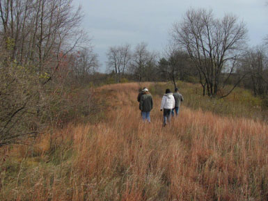
Esker. This refers to a long, thin, snake-like hill of sand and gravel that was likely formed by a stream that carried rocks and sediment within a glacier. I know of one esker in McHenry County, although I am sure there are others. Sadly, it is likely that local eskers were removed as part of gravel mining operations. Eskers are treeless and very well-drained, providing ideal habitat for a unique assortment of grasses and wildflowers that are adapted well to perpetual drought conditions. The photo was taken on an esker northeast of Hebron. The reddish grass is little blue stem, and you can see how it covers the top of the hill. Where the grass ends, the land slopes sharply away.
Kettle. This is a depression in the landscape that was caused when a chunk of ice broke off from a retreating glacier. Glacial “outwash” (debris) then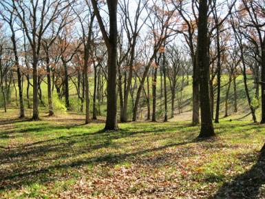 covered the ice chunk, and once the ice melted, a depression was left behind. Some kettles are lakes, as they hold water throughout the year. Others lie atop deep sand and gravel deposits, providing rapid infiltration of any rain or snowmelt. The latter are found throughout McHenry County. There are several kettles visible from Fleming Road and also in the Sanctuary of Bull Valley. The photo on the right is of a kettle off of Fleming Road in Bull Valley.
Kame. A kame is a small hill of sand and gravel left behind by a retreating glacier. Glacial Park in Ringwood has outstanding examples of kames. Like their cousin the esker, kames are very well drained, typically tree-less and provide habitat to a unique community of plants and insects. Kames come in all sizes, and are typically conical in shape. Many of the local kames were removed years ago for their sand and gravel.
Moraine. In its simplest sense, a moraine is a big pile of trash left behind by a glacier. As the glacier receded, all of the debris it pushed ahead of it was left behind in a heap that geologists call a moraine. Marengo Ridge just east of Route 23 in western McHenry County is a moraine that marks the western extent of the Wisconsin glacier.
Outwash Plain. Glaciers contain large amounts of silt and sediment, picked up as they scour the underlying land when they move slowly downhill. As the glacier melts, these materials are carried away and deposited in a broad area called the “outwash” plain. The Big Foot prairie area west of Harvard is an outwash plain that was formed as silt-laden melt waters flowed off the Wisconsin glacier.
So, next time you’re out for a drive, try reading the landscape. It’s a very well written old story. I think you’ll enjoy it.